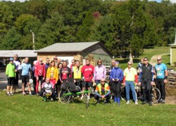
GT RidersA Grand Touring ride is a group social ride. Ride Leaders ride with the group and provide directions and support to the riders. Routes are not marked. Maps and/or Cue Sheets will be provided. Grand Touring rides are often at remote locations an hour or more distant from Central Indiana and often focus on festivals, museums, restaurants and other similar tourist attractions.

Grand Touring riders support local businesses for food and facilities. Typically ten to twenty riders will attend a Grand Touring ride. Riding is at a moderate pace and riders try to stay together. Nobody is left by themselves unless that is what the rider wants.

Grand Touring Ride Philosophy: To emphasize the enjoyment of bicycling as a group and social activity and as a method to explore and discover Indiana and other destinations.

If the weather is not suitable for riding, Grand Touring ride leaders may cancel the ride since riders usually drive long distances to attend rides. Please contact the ride leader before leaving home if the weather looks questionable. Other types of CIBA rides can be found at www.cibaride.org.

Ride Leader GuidelinesGrand Touring Ride Leader Guidelines

GT MapsGrand Touring Maps & Cue Sheets

Map and cue sheets are intended for individual personal use. If you would like to use the map and cue sheets for an organized event, please contact the ride leader.

Rides Previously Held In 2019

April

Metamora Redbud Ramble

Date: Saturday, April 27, 2019
Start Time: 10:00 am
Ride Leaders: Randy and Connie Schmucker, 317-257-5607, 317-777-9630, rsdesign@ieee.org
Route Lengths: 26 and 48 miles - hilly terrain

Start Location: Metamora, IN: Visitor parking, (Public Restrooms on top of the hill)
entry sign to parking lot reads
“ Whitewater Canal State Historic Site Indiana State Museum System Visitor Parking”.

Directions to Start: From I-465, take I-74 east. Turn left on south S.R. 229. Turn right on east S.R. 52. In Metamora turn right on Duck Creek Rd at gas station and follow 2 blocks to parking lot.

Ride Description: This tour takes in the scenic Whitewater River valley and hills in scenic southeastern Indiana while the redbuds are in full bloom. Metamora is one of the villages on the historic Whitewater canal and the Duck Creek Aqueduct can still be seen as well as portions of the canal. You can even take a ride on the canal. If shopping is your pleasure, after the ride we’ll go feast in one of the many restaurants and then shop until you drop at the abundant craft houses. Metamora's website: www.metamoraindiana.com. Contact Ride Leaders if the weather is questionable before making the trip.

Download Map

Download map/cuesheet (PDF)

May

Eastern Brown County Dogwood Meander

CANCELED / RESCHEDULED for Sunday, May 5 due to forecasts of rain in the Columbus area.

Date: Saturday, May 4, 2019
Start Time: 10:00 am
Ride Leaders: Randy and Connie Schmucker, 317-257-5607, 317-777-9630, rsdesign@ieee.org
Route Lengths: 41 and 54 miles - hilly terrain

Start Location: Columbus, IN: Jay C Food parking lot - SR 46 & Goeller Rd
Directions to start: I-65 South. Exit west on SR 46, go 0.5 miles, turn right at light, Goeller Rd, into parking lot.

Ride Description: Enjoy a nice spring day with the dogwoods and spring flowers in full bloom in the hills of western Bartholomew County and eastern Brown County. This ride will meander through Grandview Lake, Pikes Peak, Hoosier National Forest and other Indiana back road delights. Contact Ride Leaders if the weather is questionable before making the trip.

Download Map

Download map/cuesheet (PDF)

CANCELED - Greencastle Grand Tour

Canceled due to forecast for poor weather conditions.

Date: Sunday, May 19, 2019
Start Time: 10:00 am
Ride Leaders: Dave Hall, cell: 317-341-0418, dhall18@indy.rr.com
Route length: 45 - 50 miles

Start Location: Greencastle High School
Directions to Start: From Indy, take I-70 west to the Cloverdale Exit 41. Turn North(right) onto
Highway 231. Take Highway 231 into Greencastle and watch for Highway IN 240. Turn right onto IN 240 and go to Percy Julian Dr. Turn left onto Percy Julian Dr. The high school is about 1/2 mile on the left. Allow about 1 to 1 1/2 hours for drive from Indy.

Route Description: This ride leaves Greencastle and travels the backroads of Putnam and Hendricks counties with visits to the small towns of Fillmore and Amo. We will stop for snacks and rest at the Amo general store. The ride will leave Amo behind and head for the recreation area of Heritage Lake and another snack and rest stop at the Pizza Den. From the marina, we will make our way back to the start in Greencastle. Route is moderately hilly with long, flat stretches in between- no killer hills- and light motor vehicle traffic. Contact Ride Leaders if the weather is questionable before making the trip.

June

Metamora Strawberry Fest

Date: Sunday, June 2, 2019
Start Time: 9:30 am
Ride Leaders: Randy and Connie Schmucker, 317-257-5607, 317-777-9630, rsdesign@ieee.org
Route Lengths: 26 and 48 miles - hilly terrain

Start Location: Metamora, IN: Visitor parking, (Public Restrooms on top of the hill)
entry sign to parking lot reads
“ Whitewater Canal State Historic Site Indiana State Museum System Visitor Parking”.

Directions to Start: From I-465, take I-74 east. Turn left on south S.R. 229. Turn right on east S.R. 52. In Metamora turn right on Duck Creek Rd at gas station and follow 2 blocks to parking lot.

Ride Description: Strawberries! Ice Cream! Shortcake! Whip Cream! Today is Metamora's Strawberry Festival. This tour takes in the scenic Whitewater River valley and hills in scenic southeastern Indiana. Metamora is one of the villages on the historic Whitewater canal and the Duck Creek Aqueduct can still be seen as well as portions of the canal. You can even take a ride on the canal. After the ride we will find the strawberries and eat and listen to folk music. If shopping is your pleasure, shop until you drop at the abundant craft houses. Metamora's website: www.metamoraindiana.com. Contact Ride Leaders if the weather is questionable before making the trip.

Download Map

Download map/cuesheet (PDF)

July

Summertime Hills Frolic

Date: Saturday, July 20, 2019
Start Time: 9:00 am
Ride Leaders: Randy and Connie Schmucker, 317-257-5607, 317-777-9630, rsdesign@ieee.org
Route Lengths: 41 and 53 miles - hilly terrain

Start Location: Columbus, IN: Jay C Food parking lot - SR 46 & Goeller Rd
Directions to start: I-65 South. Exit west on SR 46, go 0.5 miles, turn right at light, Goeller Rd, into parking lot.

Ride Description: Wander and roll through the scenic hills and views around Beck's Grove, Pike's Peak and Orchard in western Bartholomew county and eastern Brown county. There will be lots of shade. The lunch stop at Trails End features handmade sandwiches. After rolling around Grandview Lake refresh yourself with ice cream and goodies at Jay Cs. Contact Ride Leaders if the weather is questionable before making the trip.

Download MapDownload map/cuesheet (PDF)

August

Grand Touring Camping Weekend in Madison Indiana
Bikes, Blues, and Barbecue…

Date: August 16 - 18, 2019
Start Time: 9:30 am ride on Saturday and 10:00 am on Sunday
Start Location: Clifty Falls State Park (entrance fee for park)
Ride Leaders: Kerry and Pam Knipp kpknipp@sbcglobal.net, 317-796-8004
Ride Length: 50 miles
Directions: Take I 65 South to SR 256. Go east about 20 miles to SR 62. Go left (north) 2.5 miles to Park Entrance and turn right. (Approximately 1.5 - 2 hour drive from Indy)

Ride Description: Join us for the Madison Ribberfest. Camping, Grand Touring, Barbeque, Blues Bash, too much fun for any one weekend. Join us for an action packed weekend for the entire family. It’s a camping ride. It’s a touring ride and a whole lot more. Come for all or any of the activities. Contact Ride Leaders if the weather is questionable before making the trip.

Friday, August 17
Drive down after work and camp or stay at a local B&B. Get a good night’s sleep or go to the first night of the Ribberfest. NOTE: There are only 165 total campsites [59 primitive] in the Park. Reservations have been made and paid for by Ciba with three non electric sites. Contact ride leader Kerry Knipp if interested in using one of these sites. Campsite parking passes will not be available until ride leaders check-in, but with a reservation number you will be allowed to set up.
(www.indiana.reserveworld.com)

Saturday, August 18, 9:30 am departure
Start the weekend on Saturday morning from Clifty Falls State Park at the campground parking lot at 9:30 am, www.in.gov/dnr/parklake/2985.htm, for a nice 50 mile hilly ride (similar route as “A Pleasant Tour of China”) in the Madison area. (Think Hilly Hundred effort!) Work up an appetite to PIG OUT at the Madison Ribberfest Barbecue, Blues and Balloons Festival. Check out some great blues acts as well as some of the best BBQ this side of the Mississippi. [Bring your lawn chairs!] Entrance fees for Barbecue and Blues fest: purchase your tickets for $30.00 for both nights while supplies last to receive $10.00 in food coupons. Cost of ticket on same day of event is $30.00. www.madisonribberfest.com

Stay the night in the Madison area by camping at Clifty Falls State park or pamper yourself to one of the charming B&B’s in the Madison area. www.visitmadison.org

Sunday, August 19, 10:00 am departure
Start ride at Clifty Falls State Park at 10:00 am at the main north gate for a leisurely 40 mile flat to rolling ride. The highlight of today’s ride will be at the lunch stop, Streamcliff Herb Farm, www.streamclifffarm.com, Indiana’s oldest herb Farm in the Sprigs and Twigs Tea Room. All items found on the menu are created using herbs from our gardens. As a special touch they garnish each plate with an edible flower or herb. After lunch, stroll through their many different gardens or browse their gift shops. Reservations will be for 12:00 pm (right when they open) and are strongly suggested. Please email to let us know if you plan on coming so we can make sure we have enough for the group OR stay back at Clifty Falls and enjoy one of the many hiking trails the park has to offer.

September

Metamora Ramble - The Sequel

Date: Saturday, September 7, 2019
Start Time: 9:30 am
Ride Leaders: Randy and Connie Schmucker, 317-257-5607, 317-777-9630, rsdesign@ieee.org
Route Lengths: 30 and 51 miles - hilly terrain

Start Location: Metamora, IN: Visitor parking, (Public Restrooms on top of the hill)
entry sign to parking lot reads
“ Whitewater Canal State Historic Site Indiana State Museum System Visitor Parking”.

Directions to Start: From I-465, take I-74 east. Turn left on south S.R. 229. Turn right on east S.R. 52. In Metamora turn right on Duck Creek Rd at gas station and follow 2 blocks to parking lot.

Ride Description: Return to Metamora in scenic southeastern Indiana for another tour of the Whiteriver Valley in late summer. Wander the valleys and ridges and admire the spires of Oldenburg. Metamora is one of the villages on the historic Whitewater canal and the Duck Creek Aqueduct can still be seen as well as portions of the canal. After the ride savor some ice cream or quaff some coffee at the Smelly Gourmet. Metamora's website: www.metamoraindiana.com. Contact Ride Leaders if the weather is questionable before making the trip.

Download MapDownload map/cuesheet (PDF)

Greencastle Grand Tour

Date: Sunday, September 22, 2019
Start Time: 10:00 am
Ride Leaders: Dave Hall, cell: 317-341-0418, dhall18@indy.rr.com
Route length: 45 - 50 miles

Start Location: Greencastle High School
Directions to Start: From Indy, take I-70 west to the Cloverdale Exit 41. Turn North(right) onto
Highway 231. Take Highway 231 into Greencastle and watch for Highway IN 240. Turn right onto IN 240 and go to Percy Julian Dr. Turn left onto Percy Julian Dr. The high school is about 1/2 mile on the left. Allow about 1 to 1 1/2 hours for drive from Indy.

Route Description: This ride leaves Greencastle and travels the backroads of Putnam and Hendricks counties with visits to the small towns of Fillmore and Amo. We will stop for snacks and rest at the Amo general store. The ride will leave Amo behind and head for the recreation area of Heritage Lake and another snack and rest stop at the Pizza Den. From the marina, we will make our way back to the start in Greencastle. Route is moderately hilly with long, flat stretches in between- no killer hills- and light motor vehicle traffic. Contact Ride Leaders if the weather is questionable before making the trip.

Ride to Rabbit Hash

Date: Saturday, September 28, 2019
Starting Time: 10:00 am
Ride Leaders: Randy and Connie Schmucker, 317-257-5607, 317-777-9630, rsdesign@ieee.org
Route Lengths: 45 miles - hilly terrain

Start Location: Boone County Arboretum - Burlington, KY
Directions: I-74 East to I-275 South to KY 237 (Exit 8) South for 9 miles to the Boone County Arboretum. KY 237 becomes Camp Ernst Road at KY 18. On Camp Ernst Road follow the Boone County Arboretum signs to the park. After turning into the main entrance turn right at first road. It's almost an immediate turn. We will be in the parking lot just south of the turn, past the butterfly garden and next to multiple baseball diamonds. Approximately 2 hour drive from Indianapolis. Burlington, KY is a little southwest of Cincinnati, OH.

Map to Boone County Arboretum: bcarboretum.org/location.

Ride Description: Scenic river views! Never heard of Rabbit Hash? Rabbit Hash is right across the river from Rising Sun! That doesn't help either? Then you've got to ride this ride! The Ride to Rabbit Hash rolls, climbs (an occasional power gear (the small chain ring!) hill) and provides scenic vistas of the Ohio River. Naturally, we'll visit Rabbit Hash and it's 1830 General Store. Also, this ride takes in the scenic area where Giant Mammoths and other "really" big creatures used to roam and the bison still roam. After the ride we'll stop for Cincinnati style chili. Contact Ride Leaders if the weather is questionable before making the trip.

Download Map

Download map/cuesheet (PDF)

October

Columbus Fall Color Tour

Date: Saturday, October 19, 2019
Start Time: 10:00 am
Ride Leaders: Randy and Connie Schmucker, 317-257-5607, 317-777-9630, rsdesign@ieee.org
Route Lengths: 40 and 54 miles - hilly terrain

Start Location: Columbus, IN: Jay C Food parking lot - SR 46 & Goeller Rd
Directions to start: I-65 South. Exit west on SR 46, go 0.5 miles, turn right at light, Goeller Rd, into parking lot.

Ride Description: Ride Bicycle Magazine's "Best Ride In Indiana". Enjoy the fall color in the hills of western Bartholomew County and eastern Brown County. The lunch stop at Trail's End features handmade sandwiches and other goodies. This ride will meander through Grandview Lake, Pikes Peak, Hoosier National Forest and other Indiana back road delights. There will be a few more hills than the spring version for the now well-conditioned legs. Contact Ride Leaders if the weather is questionable before making the trip.

Download Map

Download map/cuesheet (PDF)

November

Tour D'Greenways

Date: Saturday, November 2, 2019
Start Time: 11:00 am
Ride Leader: Dan and Mary Ann Shields, 317-750-5933, ddshields@comcast.net
Ride Lengths: 36 miles (optional short distance 1 to 25 miles)

Start Location: Monon Trail Parking Area -- Rohrer Road, ½ mile west and south of the 146th Street and Meridian Street intersection, Carmel
Directions: FROM THE SOUTH: Take I-465 on the north side of Indianapolis to the US 31 (Meridian Street) exit. Go north on US 31 to the 136th Street exit. Go left - 3/4 of the way around the first roundabout - proceeding west under US 31. Proceed straight through the second roundabout and then immediately right at the third roundabout onto Rohrer Road. Proceed north past the shopping center about one mile to the trailhead on the right. FROM THE NORTH: Proceed south on US 31 (Meridian Street) to exit 129A, north of 151st Street. From the off-ramp, turn right onto 151st Street then immediately left onto Greyhound Court. Turn right on Western Way, behind Greyhound Plaza, to 146th Street. Turn right, then after ½ mile, turn left on Rohrer Road. Trailhead will be less than a ½ mile on your left.

Ride Description: Come take a tour of the Indy Greenways! We’ll ride together in a relaxed Grand Touring pace and enjoy the scenery that only our Greenways can offer. The main route is a loop with segments on three different Greenways trails comprising almost all of the total route mileage. Halfway through the ride, we will have a rest stop at White River Gardens (cookies! apples! cider! hot chocolate! coffee!). We’ll grab a bite to eat at Scotty's Brewpub, just off the Monon Trail (just north of Carmel’s Main Street), about one mile before the end of the ride.
The optional short distances (1 to 25 miles) are simply an out-and-back on the Monon Trail as far as you care to go. Example round trip distances are 12 miles to the ice cream shop at 86th Street; 17 miles to the cafes and restaurants in Broad Ripple; and 25 miles to Fall Creek Parkway. Contact Ride Leaders if the weather is questionable before making the trip.

Download Map

Download map/cuesheet